
Many of the land surveys conducted in the original thirteen colonies were not standardized. The need for a more systematic and reliable land survey grew with westward expansion following the Revolutionary War. The federal government needed a way to parcel out and describe the location of lands for sale to settlers, and the settlers needed to be able to accurately locate and document their claims.
In 1785, the Continental Congress of the United States established the General Land Office through which land was sold, and the Office of the Surveyor General which was responsible for surveying the land. A new plan for locating, describing, and parceling out lands was devised. Thomas Jefferson was a member of the commission that prepared this plan, which stipulated that lands be surveyed prior to settlement and that the surveys be conducted in a consistent and standardized manner.
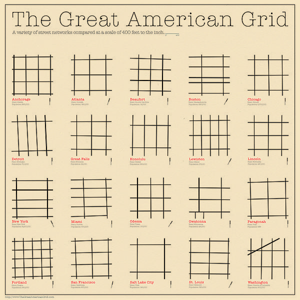
In 1786 another act of Congress directed that territory was to be surveyed into townships, six-miles square, which were bounded by lines running true north and south, and east and west. Each township was to be divided into 36 sections, one square mile each, by lines running north, south, east and west. The sections were numbered from one to thirty-six. Instructions to surveyors directed them to describe vegetation and the general character of the land they surveyed in greater detail.Most of Illinois was surveyed between 1804 and 1856. Daniel Miller and D. A. Spaulding, Jr. surveyed six townships encompassing the Midewin National Tallgrass Prairie in 1821 and 1834. These surveys include mention of an “Old Indian Boundary," a Potawatomi dwelling, and a survey of lands reserved for a Potawatomi chief.
When a deputy surveyor contracted with the government to survey land, he hired a crew consisting of one or more axemen, flagmen, chainmen, and sometimes others. The surveyors were responsible for the accuracy of the equipment, which included a compass (and later a solar compass) and the chains used to used to measure the distance between township and section corners. The surveyors measured distances in chains and links. There are 80 chains to the mile, and 100 links to the chain (a chain is 66 feet long and a link is 7.92 inches). In order to mark the regular grid system of townships and sections on the ground, the surveyors usually placed a post at each township and section corner, as well as at quarter-section corners halfway between the section corners.
To help locate the post, or in the event that the post was destroyed, the surveyors blazed “witness” trees near the post in forested areas or built an earth mound with trenches around the post in prairie. The surveyors recorded all or some of the blazed trees in their notebooks, and these are known as bearing trees. It is these bearing trees that are so valuable to modern-day ecologists for reconstructing the vegetation at the time of the survey. Bearing trees were not a random sample of the forest trees, however. Surveyors chose them based on size, proximity to the corner post, and probability of long-life, as the purpose of a bearing tree was to help relocate the corner in the future. However, in any area the choice of trees was limited, and the trees recorded were in fact there. The surveyors recorded the bearing trees by common name (e.g., “black oak”), diameter in inches, distance from the corner post in links, and compass bearing from the post.
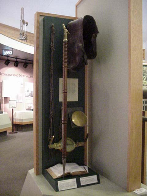
 Abraham Lincoln was a surveyor in Illinois. His equipment in the photo on the right.
In 1786 another act of Congress directed that territory was to be surveyed into townships, six-miles square, which were bounded by lines running true north and south, and east and west. Each township was to be divided into 36 sections, one square mile each, by lines running north, south, east and west. The sections were numbered from one to thirty-six. Instructions to surveyors directed them to describe vegetation and the general character of the land they surveyed in greater detail.Most of Illinois was surveyed between 1804 and 1856. Daniel Miller and D. A. Spaulding, Jr. surveyed six townships encompassing the Midewin National Tallgrass Prairie in 1821 and 1834. These surveys include mention of an “Old Indian Boundary," a Potawatomi dwelling, and a survey of lands reserved for a Potawatomi chief.
When a deputy surveyor contracted with the government to survey land, he hired a crew consisting of one or more axemen, flagmen, chainmen, and sometimes others. The surveyors were responsible for the accuracy of the equipment, which included a compass (and later a solar compass) and the chains used to used to measure the distance between township and section corners. The surveyors measured distances in chains and links. There are 80 chains to the mile, and 100 links to the chain (a chain is 66 feet long and a link is 7.92 inches). In order to mark the regular grid system of townships and sections on the ground, the surveyors usually placed a post at each township and section corner, as well as at quarter-section corners halfway between the section corners.
To help locate the post, or in the event that the post was destroyed, the surveyors blazed “witness” trees near the post in forested areas or built an earth mound with trenches around the post in prairie. The surveyors recorded all or some of the blazed trees in their notebooks, and these are known as bearing trees. It is these bearing trees that are so valuable to modern-day ecologists for reconstructing the vegetation at the time of the survey. Bearing trees were not a random sample of the forest trees, however. Surveyors chose them based on size, proximity to the corner post, and probability of long-life, as the purpose of a bearing tree was to help relocate the corner in the future. However, in any area the choice of trees was limited, and the trees recorded were in fact there. The surveyors recorded the bearing trees by common name (e.g., “black oak”), diameter in inches, distance from the corner post in links, and compass bearing from the post.
 Abraham Lincoln was a surveyor in Illinois. His equipment in the photo on the right.
Grid plan - Wikipedia, the free encyclopedia
en.wikipedia.org/wiki/Grid_plan
The grid plan, grid street plan or gridiron plan is a type of city plan in which streets run at right angles to each other, forming a grid. In the context of the culture of ...
Commissioners' Plan of 1811 - Wikipedia, the free encyclopedia
en.wikipedia.org/wiki/Commissioners'_Plan_of_1811
The Commissioners' Plan of 1811 was the original design plan for the streets of Manhattan, which put in place the grid plan that has defined Manhattan to this ...
PlanGrid - The Best Construction App for Viewing Plans on the iPad
www.plangrid.com/
PlanGrid allows you view, annotate, and communicate all your project information right from the field.
Images for the grid plan'
- Report images
Grid plan
www.princeton.edu/~achaney/tmve/wiki100k/docs/Grid_plan.html
The grid plan, grid street plan or gridiron plan is a type of city plan in which streets run at right angles to each other, forming a grid. In the context of the culture of ...
Manhattan Grid Turns 200: Five Reasons We Still Love The Master ...
www.huffingtonpost.com/.../manhattan-grid-turns-200-_1_n_8...Mar 22, 2011 – Manhattan's famous grid plan turns 200 years old today and the New York Times has a great interactive map showing how closely the plan in ...
Grid - Global Site Plans
www.globalsiteplans.com/the-grid/
Creating Industry Distinction in Architecture, Engineering, Environmental Non-Profits, Landscape Architecture, & Urban Planning.
Manhattan's Rectangular Street Grid Turns 200 - NYTimes.com
www.nytimes.com/2011/03/21/nyregion/21grid.html?pagewanted=all
Mar 20, 2011 – What made the grid plan, formally called the Commissioners' Map and Survey of Manhattan Island, so farsighted was that in 1811 a vast ...
Speed Levitch: The New York City "Grid Plan" - YouTube
www.youtube.com/watch?v=9awJCyjt550
Mar 2, 2006 - Uploaded by speedssisterSpeed Levitch expresses his thought on the New York City "Grid Plan".- More videos for the grid plan' »
Why the grid is a great asset to our cities | Sustainable Cities Collective
sustainablecitiescollective.com/theamericangrid/.../fallacies-against-grid
Jan 30, 2012 – I have heard many criticisms about the grid plan–It's boring, It's unnatural, et cetera. Having happily visited and lived within gridded towns and ...
Isolation in the Grid Plan | Museum of the City
www.museumofthecity.org/exhibit/isolation-grid-plan
Citizens of Portland, Oregon have supported a local phenomenon that challenges sociological and environmental effects of the grid plan. Every spring, the ...
http://planningnews.blogspot.com/2011/12/grid.html http ...
https://plus.google.com/104850252419834437007/.../Fa3pJBi6...
Craig Hullinger - LimitedDec 18, 2011 – http://planningnews.blogspot.com/2011/12/grid.html · http://cityplanningnews.com CityPlanningNews.com: The Grid


